Mardi Gras Parade

IMG_3252


It seems that New Orleans & Alabama are disputing over who actually had the first Mardi Gras, who knew!

Those who believe New Orleans started Mardi Gras say it took place on March 3, 1699, when French explorers Bienville and Iberville put down stakes on the west bank of the Mississippi River, about 60 miles downriver from the site of what would become the Crescent City, “La Pointe du Mardy Gras,”

Those who side with Mobile, however, claim New Orleans has it all wrong. They say the first Mardi Gras celebration in America took place in 1703, when a group of French soldiers held an impromptu celebration in the settlement of Mobile.

untitledimages

Today both New Orleans and Mobile continue to celebrate Mardi Gras.  All we know for sure is that, for 300 years, America has loved Mardi Gras.

Dave & I went to our 1st Mardi Gras parade on Tuesday, known as Fat Tuesday, right down the street from where we’re staying.  As you can tell by the pictures It was a lot of fun ! !

FullSizeRender - 2020-02-26T195057.249

IMG_3275

IMG_3271

IMG_3261

FullSizeRender - 2020-02-26T194917.712

IMG_3278

IMG_3277

float41

IMG_3276

By-Standers were wearing costumes and best of all, the people in the floats were throwing candy, moon pies, toys, and tons of beads into the crowds! 

Why beads you ask?  It is rumored that when Grand Duke Alexis visited in 1872, his welcoming committee handed out purple, green, and gold beads to the party-goers that year, as they were the colors of his home.

The trio of shades came to symbolize the festivities and were later given meanings: purple for justice, gold for power, and green for faith.

got beads

It was a really fun time.  We met a lot of great people and got lots and lots of beads!

IMG_3282IMG_3281

IMG_3284


Our collection of Mardi Gras Beads !!


ALA


GULF STATE PARK CAMPGROUND

We are now pretty settled into Gulf State park, which is in Gulf Shores Alabama, right along the Gulf of Mexico. This is our first time in good ole Alabamie. The campground itself is kind of in the middle of the park. The main campground road is almost two miles long, with eleven off shoot roads to other loops. All the spots are paved, have water, sewer and electric. There are 496 very large Rv spots here, way more than any state parks.  Also 10 big bathroom buildings about 40 x 60 feet. They remind me of a bunker, they are made of concrete with concrete roofs, I guess for the hurricanes here. Also a huge laundry building, and get this a huge POOL, yep a pool, never heard of one being in a state park. The main entrance is open 24 hours a day. Normally you can only stay at state parks for two weeks at a time. It is the same here except for November thru April, when you can stay as long as you want, and a lot of people do. We have started to explore the park, and will post on that next.

FullSizeRender - 2020-02-24T135229.270

IMG_1732

Campground is in the middle, right above middle lake.

IMG_1731

We have a nice 100 foot pull thru

IMG_1730

GULF SHORES ALABAMA

We are now at Gulf State park in Gulf Shores Alabama. Today I drove 169 miles in the rain. It has rained all day here, and a cold front is coming in. Hello Alabama, good bye Florida. It will be about 10 degrees colder than normal for the next week. So no more 70’s and 80’s only high 50’s or so. What in the world was I thinking when I made reservations last year, oh well. In four days I have drove 725 miles or so, and I have to say i am tired, my neck is sore and my back hurts. It’s tough driving days in a row, you never get to set up all the way in the Rv, and you really never get to see much of where you are for the night.  The park here is right on the beach with a main road running through it, so the campground is on the other side from the beach. More on the park in a few days. We will be here for two weeks, so time to sit back have a few drinks, and hope we get a few warm days.

FALLING WATERS STATE PARK

Today we traveled west to Falling Waters State park, driving 191 miles up the hills of Florida. That’s funny, Hills. We are now in the panhandle of Florida, about 100 miles from the Alabama border. Yes, in the hills, This area is the highest elevation in the state about 324 feet above sea level. The park is pretty nice, only has 23 sites. The draw here is the highest water fall in Florida, almost 100 feet. The water falls into a deep hole and then just disappears under the limestone rock, pretty neat.

One thing that caught me by surprise is that it is an hour earlier here. So far have not got used to that.

Today I was a little bit nervous about driving, have no idea why, even Melissa commented on it. Tomorrow one more day of driving, then staying put for two weeks, at Gulf Shores state park in Alabama.

IMG_3121

IMG_3122

IMG_3129

The water falls, not running to swiftly today

IMG_3126

Sinkhole carved out by the water, no one knows where the water goes

IMG_3132

Lake from which water travels to the falls.  You can see the beach at the other side of the water.

IMG_3143

Melissa gives a HOOT

STEPHEN FOSTER STATE PARK

Now at Stephen foster state park for the night, drove 196 miles non stop today. Before we left Hillsborough River state park this morning we talked to the Vol. Coordinator, about working at the park. We will send in our resume and see what happens. It always helps when you meet them in person. This park is nice and we have been here before, it is about 30 miles south into Florida from Georgia. So we are no longer into the heart of Florida. Tomorrow we head west into the panhandle of Florida, for a stop over at Falling Waters state park for one night, then into Alabama, at gulf shores, Thursday for two weeks. That’s it for now.

HILLSBOROUGH RIVER STATE PARK

This morning we left Ortono, and headed to Hillsborough River state park, which is about 40 miles east of Tampa. Drove a total of 171 miles, things went well. We are only here for one night, and head north tomorrow. We got a nice pull thru although I had to jockey a little to get to the electric box. Sites here are very large, although the camp roads are kind of tight. Total of 84 sites, all pretty much along the Hillsborough river. This is also a very large park with a lots to do, from biking to hiking, to canoeing the river etc. and there is also a swimming pool. A bit out in the middle of no where. We are no longer on concrete pad sites, here they are sand and grass, which is fine, also we are now back into the hardwood hammocks of Florida with lots of live oak trees covered in moss. Next year on our way out of Florida we will stay here a few days and explore.

Today had one bummer though. Got up this morning and got my phone, dead as a door nail. Fully charged and dead, could not do anything, tried all the usual stuff, turning it on off etc. Melissa’s phone did the same thing last year at only two months old. They had to send her a new one. so I guess they will do the same for me. Cannot have it looked at till Friday when we are in Gulf Shores. Real bummer man.

Pics of our site.

IMG_3110

IMG_3112

IMG_3111


Last Day at Ortona COE campground

Today is our last full day at Ortona Corp of Engineers Campground.  It is very nice and clean, we will definitely stay at other COE Parks. It’s a very low key place, nice to just relax and definitely get away from it all.  There are lots of birds to watch, fish to catch and boats to see going through the locks.  We even saw some otters playing in the water.  Otter than that, there isn’t a lot to do.

army

IMG_3059

Down by the pier a popular fishing spot.

pole

fish

IMG_3033

            + + + + + + + + + + + + + + + + + + + + +

FullSizeRender - 2020-02-05T181707.112

Walking to the campground from the road

IMG_3036

Getting closer to the campground. It was  nice to ride your bike and walk on the road to the campground.

FullSizeRender - 2020-02-15T213609.171

I don’t think that Dave mentioned our neighbors!  Their names are Cowlick on the left and Sir-Loin on the right.  Their advice to us was “Eat More Chicken.”

                  X X X X X X X X X X X X X X X X X X X X X X X X X X X X X

We saw some beautiful sunsets at Ortona…..Here is one of them

IMG_3027IMG_3030 (1)

IMG_3031

sun


ORTONO LOCK AND CAMPGROUND

We have now been here for 10 days. We leave here Monday for three days of travel to Gulf Shores Alabama on Thursday. It has been unusually hot here, about 88 to 90, every day, normally it is about 77 or so. It also has been windy here, 20 Mile per hour winds and higher every day. If you stay out in it for a few hours or so, it kind of beats you up a little. We are sort of out in the middle of no where to. It is about a twenty minute drive to the nearest town, which is La Belle. We are surrounded by farm land and pastures, with cows, horses ,donkeys and even pigs. We are a mile off the main road, which runs east, west. The campground is right on the Calooseahatchie river, right at the lock ,and dam. The campground road is about 1/4 mile long with a loop, and campsites on either side, 52 in total. We have water, electric, but no sewer, they have a dump station. There also is not really anything to do here, unlike Cypress trails. So it is quiet, with no kids and we have found that most here are much older than us. I mean in there 70’s. It is however a pretty nice place to stay. It got better the day we arrived. When I made reservations six months ago, I paid $30.00 per night. When we got here I read that if you have the America The Beautiful pass, it is only $15.00 a night, so I got a refund of $180.00. that was real nice. So our stay here ,and in Florida this year is almost over, by Thursday we will be in Alabama, and from there head north.

A LITTLE HISTORY OF THE DAM AND LOCK.

GreenBoxImage_Ortona

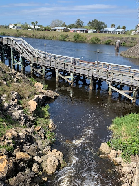
Campground is on the left side, and corps headquarters on the right.

The dam and lock were built in 1937, to help control flooding and help with navigation of boats in the river. Before the locks the river had a very swift current as it made its way to the gulf. The Calooseahatchie river runs east, west and somewhat severs Florida in half.  The river starts running west from Lake Oakachobie, which is on the eastern side of Florida. The river runs about 60 miles or so to the Gulf of Mexico. Which is where Fort Myers is. There are three locks along the river, Ortono is the middle lock. The river is average about 200 yards wide, until it gets close to Fort Myers, where it has been dredged and widened quite a bit. The river also has many man made canals that run into it to keep this part of Florida from becoming a swamp again, which is what it was until the early 1900’s. The Ortona lock drops or lifts boats 8 feet, the dam keeps the water level higher on the one end than the other.

We got to see a boat come into the lock, it is pretty cool to see and I can only imagine the power it must take to open and shut the locks.

IMG_1725

This is the walk way over the lock, water on the right is higher than on the left.

IMG_1720

Lock is open about one foot with water pouring into the channel to fill it up, way down on the left is another lock which is closed.

IMG_1723

Water level in the channel even, they open the lock and the boat comes in.

IMG_1724

Boat coming in, the lock behind him is being shut, the lock way down on the end will be opened soon and the boat will drop to that level of water.

IMG_1726

Water starting to flow out of the end lock.

IMG_1728

Now the boat is down to the water level, and the lock is opening.

IMG_1729

Away he goes. The whole process took about twenty minutes. You can see further down two smaller boats ready to come into the locks and get lifted up. So there you have it, the working of a lock. Also there is no fee to the boater to go through the lock. I am not sure how all that is paid for.

On a final thought, it is bittersweet, we are leaving Florida. It has been a good time here, but we are heading places we have not been before, this spring. It also will not be as warm where we are headed. It will only be in the 60’s but I guess that will be alright. We have a lot planned so we are excited to get going.


Side by side or miles apart real Friends are always close to the heart!

FullSizeRender - 2020-02-13T133321.924

Our Dear Friends, Mary & Don are staying in Kissimmee FL and we’re in Labelle FL, so we met half way at Sebring Fl.  It’s fun to see wonderful old friends whom you’ve know well, “forever”  Mary & I have been friends since high school.

IMG_3071

IMG_3068

Pier

Walked around Sebring a bit, had ice cream at Sebring Soda for lunch, my kind of lunch! And left to go to Highland Hammock State Park.

h h sign

In March 1931, the 1,280 acre park opened. … When Florida’s state park system was established in 1935, Highlands Hammock became one of the state’s first parks. It is one of eight original CCC parks in Florida.

The first trail we took was the Alexander Blair Big Oak Trail   it has one of the largest trees in the park.  It’s 1000 years old and measures 36ft around the trunkIMG_3074IMG_3076

trunk

                                 * * * * * * * * *


 IMG_3078

Next trail was the Cypress Swamp Trail also know as the “Catwalk”

The boardwalk here is a stretch of an old-time catwalk.  It was built the way the first trails in the state were built.  Sort of like  a balance beam of sorts, zigzags through the cypress along the creek’s edge. The park keeps it this way because it shows the simpler days of Florida tourism.

  IMG_3080

IMG_1711

cat

Last trail was the Ancient Hammock trail

 The Ancient Hammock Trail takes you to the oldest section of the Hammock. It has cabbage palms and live oaks up to a thousand years old and more. There is also a bridge built by CCC on the trail.


CB

IMG_1709

This prayer was on a sign at the end of the trail

The Prayer of the Woods

I am the heat of your hearth on the cold winter nights, the friendly shade screening you from the summer sun, and my fruits are refreshing draughts quenching your thirst as you journey on.

I am the beam that holds your house, the board of your table, the bed on which you lie, and the timber that builds your boat.

I am the handle of your hoe, the door of your homestead, the wood of your cradle, and the shell of your coffin.       I am the bread of kindness and the flower of beauty.     ‘Ye who pass by, listen to my prayer: Harm me not.

At the end of our visit to the park we stopped at the CCC museum to check out how they lived, worked and the tools they used.

IMG_3085

C C C building

The Civilian Conservation Corps helped to build and shape this park and other national and state park systems we enjoy today. (CCC) was a voluntary public work relief program that operated from 1933 to 1942 in the United States for unemployed, unmarried men. the CCC planted more than three billion trees and constructed trails and shelters in more than 800 parks nationwide during its nine years of existence. The CCC helped to shape the modern national and state park systems we enjoy today.       Three Cheers for the CCC!

The day finished with a dinner at The Sebring Diner.  Our dinners were real good, or like they say in the south. Real Good Grub!

The day was over already! Time sure does fly when your with old dear friends. Had a great time and a lot of laughs!     Good By For Now

untitled


ORTONA LOCK CAMPGROUND

We are now at the Ortono lock campground. This is a corps of Engineers park, right along the Caluchahatchie river. I will post about the lock and campground another day. This campground is east of Fort Myers. It was only 38 miles to get here today. We have a nice spot near the end of the campground. Nothing like the hustle, and busell over at Cypress Trails. The closet town is La Belle, which we went through coming here. There are a few Rv parks there, so we will be checking them out for our stay next winter. Below is a few pics of our spot and campground.

IMG_3019

IMG_1697

IMG_1701

IMG_1698

IMG_1700

IMG_1699

The lock and dam at the river

FullSizeRender - 2020-02-05T181707.112

Our back yard, no big Rv’s, or golf carts just cows and pasture.

IMG_3015

IMG_3021

The moon is a rising.